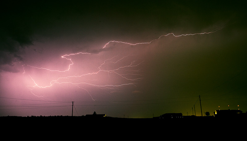
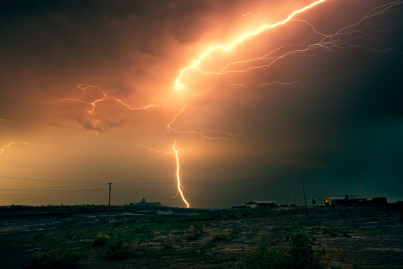
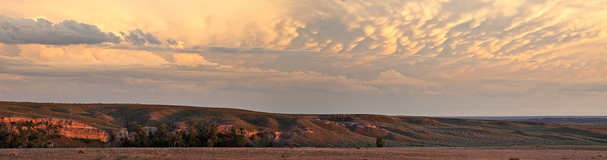
Huge lightning bolt lights up the landscape over the Colorado plains.
The storms that resulted in serious flooding over parts of southeast Colorado last night also put one heck of a light show last night. I spent about half an hour taking close to 100 5-20 second exposures from in back of my house, looking southward towards Pueblo. Almost every shot captured a lightning bolt, but this one above was extra huge–so bright it lit up the prairie for a brief second. To give you an idea of just how powerful this one strike was, the first shot was probably the second strongest of the nearly 100 strikes I captured. Quite an electric night!
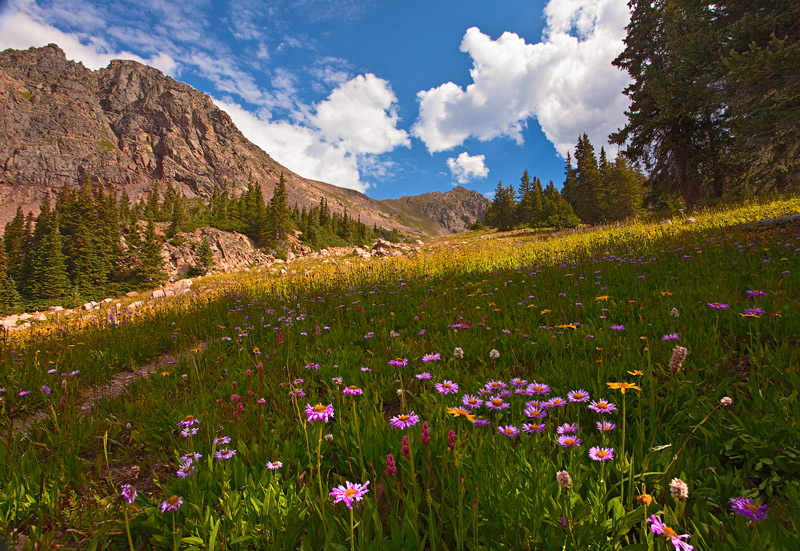
August brings wildflowers to the Deluge Lake Trail near Vail.
Every summer, I always take one hike for which I leave most of my camera gear behind. I take my camera and one lens; no tripod, no other lenses or filters. It’s a liberating exercise that reminds me of why I got into nature photography in the first place. No worries about getting good light or a good composition; just a pleasant day in the mountains.
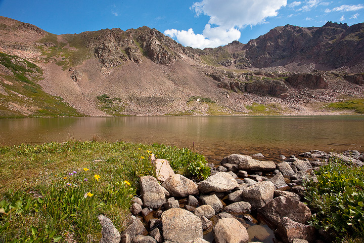
I traditionally have climbed a 13,000 foot peak for this venture; leaving behind the gear lightens my pack by at least 10 lbs, and makes it easier to take on a challenging route. But this year my fitness level is rock bottom, so I scaled back my ambitions and settled on one of the steep lake trails near Vail Colorado. The Deluge Lake Trail climbs over 3,400 vertical feet in 9 miles round trip, and it feels like more than 9 miles since most of it is above 10000 feet where the air is thin. I got an early start and went slowly, taking nearly three hours to reach the lake. It was a great day to be out in the mountains, and the wildflowers were still peaking in the meadows, along with some wild berries. I was happy to come away with one decent hand held shot, since I really didn’t expect to do much photography at all, just got some good exercise! On the way out I took some photos of Lake Dillon at sunset–I used a tripod this time. 🙂 The destination!
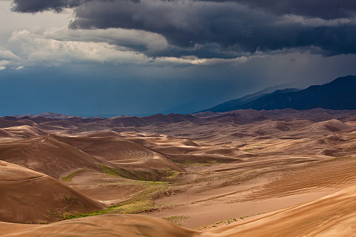
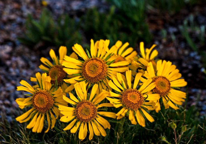
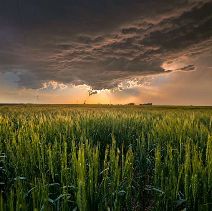
August is my favorite month to photograph the Great Sand Dunes National Park. The monsoon is in full swing, and afternoon thunderstorms intensify the dramatic lighting in the dune field. Sunflowers bloom for a brief time and provide a splash of color amidst the desert landscape, and are symbols of life and perseverance against adversity. Recent heavy rains convinced me that the flowers would be blooming, so I headed out to pursue my goal of catching the ultimate sunflower-and-dune image. I’ve been making this pilgrimage every year for the past 7 years or so, and it never disappoints me.
As I drove up the dunes highway, I could already see a huge thunderstorm building over the Sangre de Cristo Mountain range that looms behind the dunes. A brief spurt of hail pelted my car, and I could see streaks of white on the dunes from the passing hailstorm. After stopping at the Visitor Center to say hi to some friends who work at the park, I headed out to the dune mass to look for some good sunflowers. The flowers bloom throughout the dune mass, but finding the ‘perfect’ flowers that accentuate the dramatic landscape is a bit like looking for a four-leafed clover. But it didn’t take long to find some great subjects.
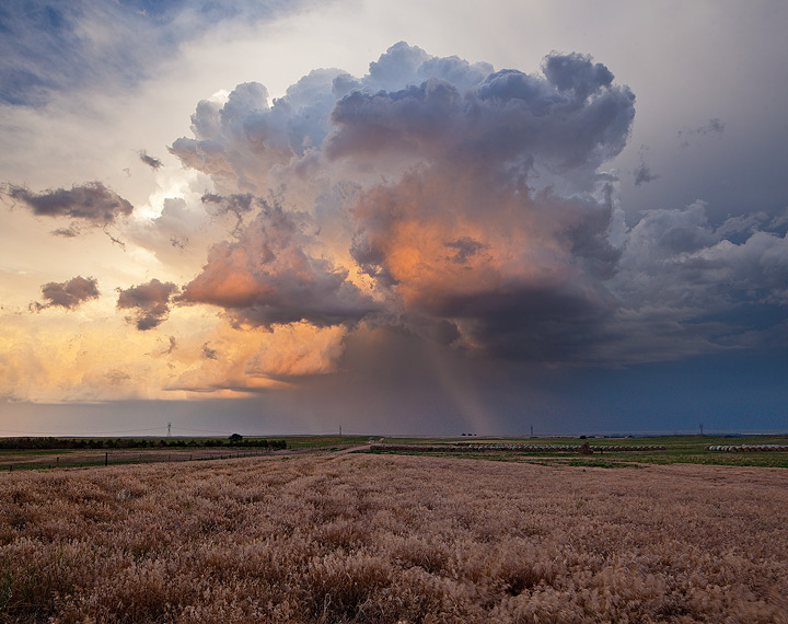
I continued to climb, to a subsidiary dune next to High Dune, a prominent spot that is the destination for many visitors to the park. As I reached the summit of the 700 foot tall dune, I started to hear thunder reverberate from the nearby mountains. Thunderstorms were building all around the dune mass. I saw a couple of flashes hit the mountainsides. As the storm continued to build, the light on the dune became more and more dramatic; light and shadow intensified along with the colors in the late afternoon light.
I was torn between sticking around as the light and colors continued to intensify, or rushing downward to relative safety. I wasn’t the tallest point on the dunes, but I definitely wasn’t in a safe spot. The wind began to pick up and a few drops of rain pelted my face, along with waves of sand blowing off the dunecrests. I grabbed a couple final shots, including the one posted first here, and then quickly headed downwards. The view from the top of the dunes was incredible; the recent rains really enriched the subtle colors of the dunes, and the vegetation around the dune mass was as green as I have seen there.
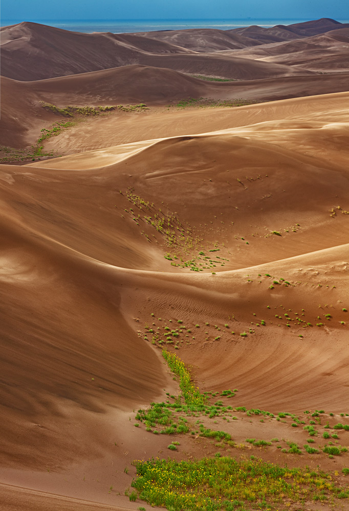
On my way down, I spotted a lone sunflower that really stood out from the others. As the wind continued to bear down on me, I quickly stopped and set up my tripod low to the ground. A trick I have learned from previous shoots is to shoot in the direction of the wind to minimize the blur on the flower. The light was intense; I had found my elusive subject!
Now that thunderstorms had chased me from the dunes, I drove to the south side of the park in hopes of catching a rainbow. My luck panned out as a brief rainbow appeared over the distant dunes. Just another great August afternoon at the Great Sand Dunes!
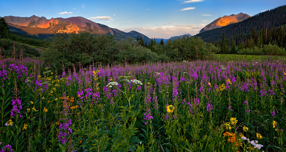
There is nothing that quite compares to the crazy display of wildflowers that occurs in the Colorado high country every year during the mid-summer months. The peak usually happens sometime in mid July to early August, so with a week’s vacation to work with this year, I just had to spend a few days worth in the annual quest for wildflower extravaganza.
I have photographed most of the ‘hot spots’ for flowers in Colorado, so this year I wanted to hit a couple of new locations.
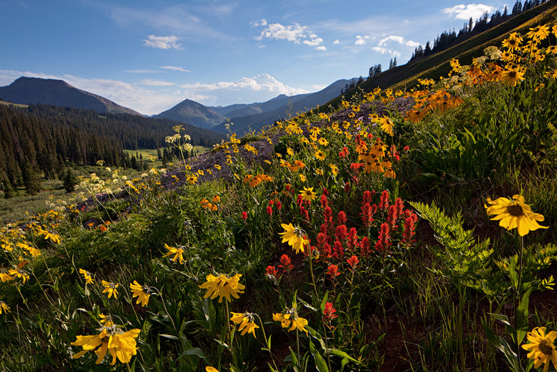
The Crested Butte area was looking good, and while I have been there in previous years, I had yet to visit the high basins north of Crested Butte. In my last attempt a couple years back, the road to the high country was blocked by an avalanche. This year, the road was open, so I headed up to Schofield Park, a trailhead ten miles up a dirt road from the Crested Butte ski resort. A sign that recommended 4WD greeted me as I drive my low clearance Ford Focus up the narrow, windy, bumpy road. So much more fun with 2WD! And all those Jeeps coming down the road in the other direction were certainly not getting the wonderful gas mileage that I was! 🙂 At one point, I asked a passing SUV if I was going to make it up the road. I noticed him glance quickly down at my tires, then he said, “If you made it this far, you’ll probably make it the rest of the way.”
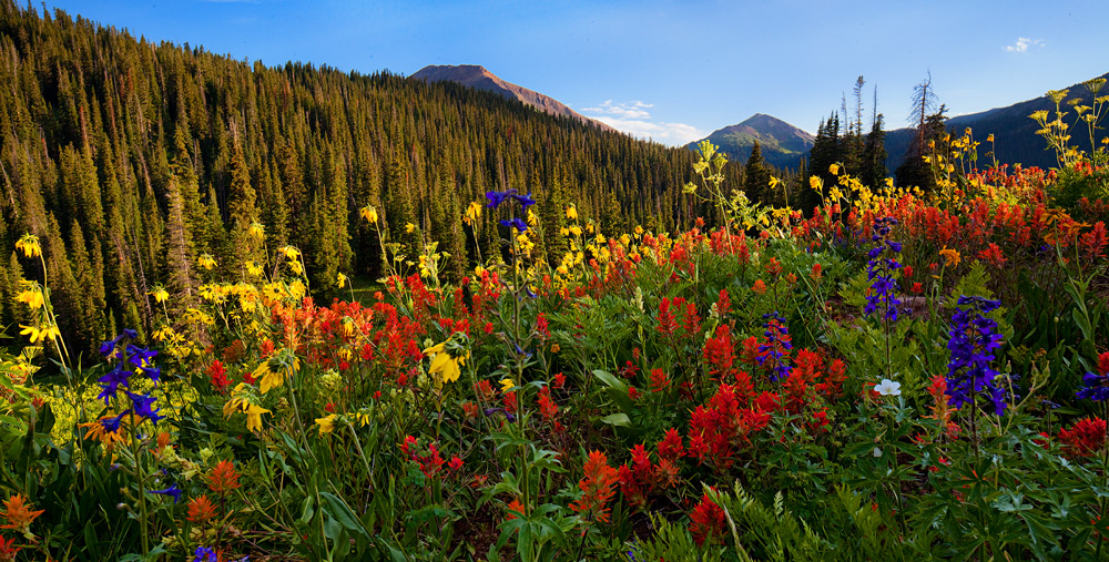
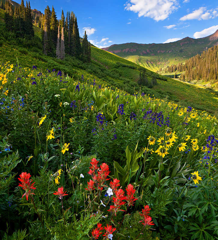
I set out on the W Maroon trail, which connects Aspen to Crested Butte via the road I had just come up. The trail quickly entered a series of basins that were just choking with flowers.
Magnificent display of wildflowers in the high basins of Maroon-Snowmass wilderness.
After hiking much of the afternoon, I decided to head back to the road for sunset, since I had scouted out some favorable locations on the way up to the trail.
Small pond reflects the summer sky along Gothic Road.
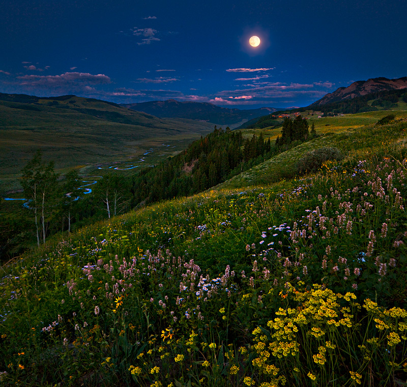
Then, as the sun set, I headed back towards Crested Butte to catch the East River in the bright light of the rising full moon. For some reason, this moon seemed bigger and brighter than many I had seen before. It was just a spectacular sight; I can only hope my photo captures some of the magic.
The full moon rises above the East Fork and Crested Butte.
I also consumed some fine brews in town, which was quite hopping for a Sunday night; a great place to meet an odd assortment of outdoor fanatics and artists,
The next day, I headed to Ridgway in the San Juan Mountains, to head up the Blue Lakes trail, one of the more spectacular trails in the state. The last time I hiked it was eight years ago, where I had about 10 pounds less camera gear, and 20 pounds less beer fat. So, I was a bit slower this time. I ended up spending most of the afternoon exploring the meadows above Lower Blue Lake, which is where the flowers seemed to be the most profuse.
I dropped back down to the campground to catch Mount Sneffels as it lit up just before sunset. Magnificent! This shot rounded off my goal of a dozen decent photos for the trip. I’m usually lucky to grab two or three per trip, so I consider it a productive trip overall. Oh, and if you’re ever in Ridgway be sure to stop at the True Grit (yes, we’re talking John Wayne) Cafe and have one of their awesome deserts. I had the blueberry pie this time. A La mode. 🙂
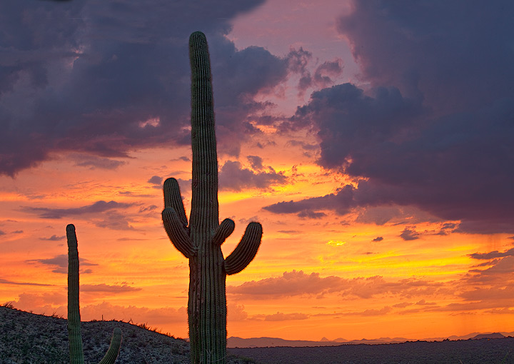
There are two things the Southern Rockies photographer looks forward to in July–wildflowers and the monsoon. With one week off to work with, I decided to get both in one week. First trip, a four day dash to Arizona to catch the monsoon. I wasn’t expecting classic monsoon, with a strange westward-moving low pressure system in the upper atmosphere (these lows usually move east!) expected to bring me my storms. I knew there would be plenty of storms, just wasn’t sure how much lightning there would be. If it rains too much, the usual surface heating gets stifled and the storms aren’t as strong. Turns out, that’s pretty much what happened–lots of storms, not so much lightning. And of course, all the big bolts happened off frame or in between clicks of my shutter!
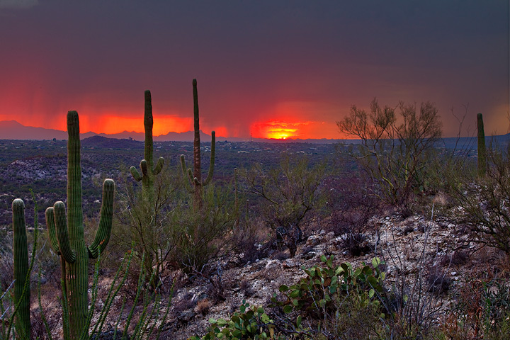
But I did get to see this classic monsoonal sunset in the Arizona desert near Tuscon.
I did grab this shot of the saguaro just after sunset, as the storms kept building over the mountains that surround Tuscon. Then I had to feign ignorance that the park closes at sunset, as a park ranger spotted my car and started inspecting it for contraband…
Saguaro shortly after sunset during a monsoonal storm.
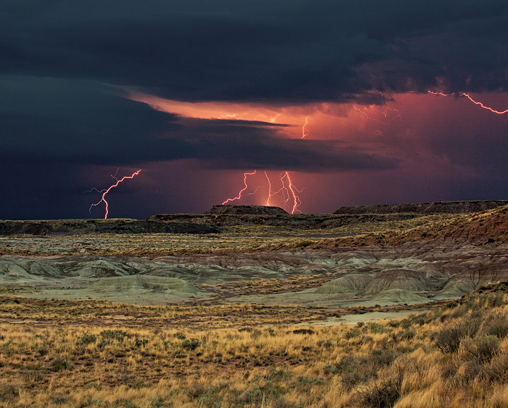
The next day, after stopping to say high to some old friends in Tuscon, I decided to head north, since there were fewer clouds in northeast Arizona and I figured that would lead to better storms. I targeted Petrified Forest in northeast Arizona. On the way, I stopped at Salt River Canyon, a spectacular landmark that I had never even heard of before. Too bad they defaced it by running a highway through it–not to mention all the garbage at every pullout along the way 🙁
I turned out to be correct about my target–a strong storm began moving into the National Park as sunset approached. But once again I was unaware that the park closed at sunset until I was already at the front gate. So of course, I kept shooting until a ranger pulled over with lights flashing, and I made my apologies and packed up, as the storm of course became highly active. I guess next time, I’ll hike in with an overnight permit…
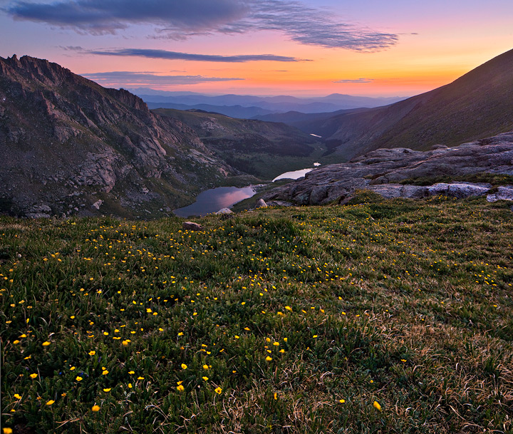
Inspired by my friend Todd Caudle’s recent photographic odyssey on Mount Evans, I decided to go get some
of my own. Unfortunately, that meant leaving on July 3d, which I soon learned is probably the busiest travel day of the summer in eastern Colorado! The trip from Pueblo to Idaho Springs ordinarily takes me less than two hours, but this time I sat, and sat, and sat, in traffic that would put Los Angeles to shame. At one point, I crawled for an hour to gain the final ten miles to the Idaho Springs exit, and the start of the drive to Mount Evans, a 14,264 foot mountain that has the highest paved road leading almost to the summit.
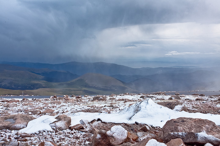
It was now late afternoon, and the thunderstorms were in full swing over the peaks. It was clear in town, but as I drove up the Mount Evans Highway the clouds opened and I was in a heavy downpour as I navigated the narrow, winding road that leads up the peak. At 12,000 feet, I started to notice bits of ice in the big drops hitting my windshield, and I knew what lay ahead. By 13,000 feet, the rain turned to driving wet snow, big wet flakes driven by strong winds. It was a full-fledged blizzard, and at one point I nearly turned around, but I knew the pavement was warm enough to keep the road mainly ice-free, and I expected the storm to clear by sunset.
Finally, I reach the observatory below the summit. One other photographer was there, flaying with his Goretex, and he shouted to me through the 50 mile-per-hour winds that he was canceling his plan to hike to the summit for sunset.
A wise decision, since the snow was about an inch deep but the wind was ferocious, and it was crazy cold for July 3d!
I waited a bit for the snow squalls to slow down, and as they moved to the south side of the peak and started pushing away from the summit, I grabbed a shot of the squalls below me, and one of the road switchbacks. With partial clearing around the summit, I started hopping boulders and took a shortcut to the west side of the summit block, a spot I had scouted in previous trips that has good views to the west. No great sunset this time, but enough clearing to make out the distant peaks. I hoped for better luck at sunrise.
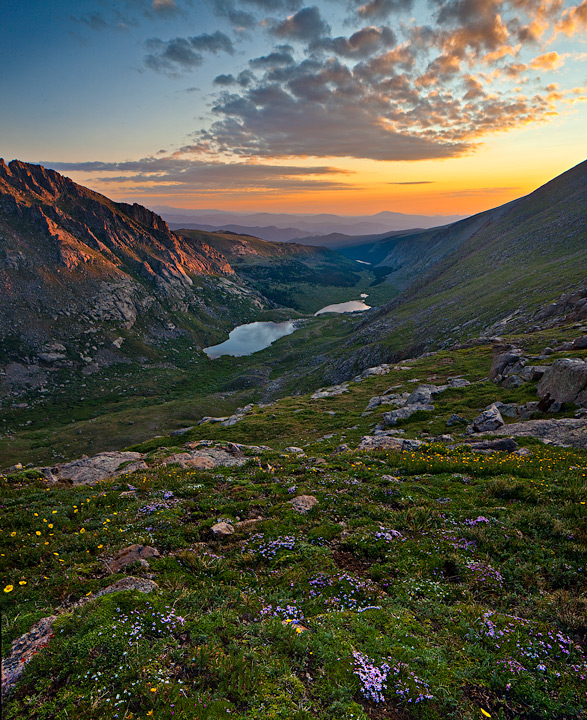
I decided to focus my sunrise plans on one of my favorite spots in Colorado to take in a sunrise, the Chicago Basin on the north side of the peak. The basin holds a number of lakes and is carpeted in flowers this time of year. The trailhead for an overlook of the basin begins at Summit Lake at 12,000 feet elevation. It was still a cold, raw morning, with thin layers of ice covering some of the tarns, but the skies were clear enough for a good sunrise. I hiked the short trip to the overlook of the basin, then hopped some more boulders to descend onto some of the flowery meadows that rise up from the lakes. I took a sequence of shots with my Canon, using my 24mm tilt-shift lens to compose larger photos of the basin. The first is about 20 minutes before sunrise, the second at peak color, then sunrise, and finally 20 minutes after sunrise. I chatted with another photographer who was taking in the spectacle, then made a dash back up to Summit Lake and grabbed some shots of the tarns, and wildflowers. A great sunrise, and a great way to spend the July 4th morning!
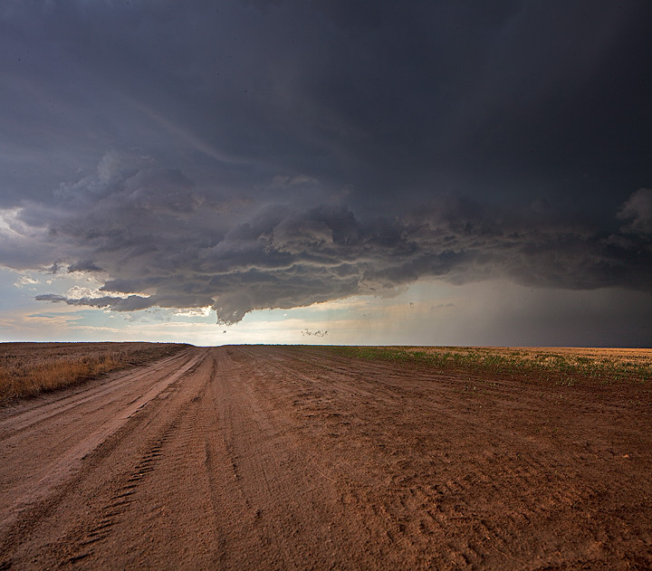
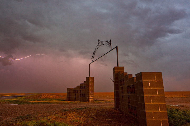
The best thing about storm chasing in Colorado is that it is usually free of the long lines of gawkers and chasers that you will typically encounter in Oklahoma or Kansas on a High Risk weekend. It’s storm chasing the Old Fashioned Way; where you don’t have to worry about being trapped on a crowded street as a rain-wrapped wedge tornado descends on you. It’s almost like the heyday of chasing when every person you met on the road was someone you knew from either a previous chase or from the community of storm chasers. So, not surprisingly, when I chased this past weekend I ran into several other storm chasers who I knew either personally or by reputation. The first chasers I ran into on Saturday were Justin Drake and Simon Brewer, the stars of The Weather Channel’s “Storm Riders”. Since our chosen storm was not terribly exciting at the time, I had a nice conversation with them about chasing and photography, two subjects that we are all pretty passionate about. Shortly after, I stopped to say high to Roger Hill, one of the most acclaimed and respected pros, on a quiet road heading south with the storm. I’ve run into Roger at least a dozen times over the last 10 years, and he’s been a bit of a good luck charm for me, probably because he holds the Guinness record for most tornadoes seen. No terrific luck this time, though–just some real pretty storms and a nice sunset over the plains of Colorado.
After a day’s break to let my tired car rest, I headed out again on Monday to chase some more Colorado storms. After making a traditional stop in Limon for some lunch at Oscar’s Bar & Grill, I caught a storm forming near the small town of Seibert, Colorado, in the midst of intersecting lines of cumulus clouds that I had picked out in a visible satellite image. I watched the clouds rapidly expand and eventually split into two separate storms, which is classic behavior for a fledgling supercell (rotating) thunderstorm. I ran into John Farley, who I knew from online forums but had never met in person, as he sat on the roadside waiting for the storm to strengthen. And Todd Thorn, another long-time chaser who runs a popular storm-chasing tour company. The storm eventually was tornado-warned after it dropped a small tornado near the town of Kit Carson. I must have been driving or simply not at the right location since I missed the landspout/tornado, but the storm had some impressive structure and I followed it all the way to the tiny town of Towner, Colorado, near the Kansas Border. I waited out a quick blast of quarter-sized hail driven by strong winds, then stopped for a bit at the town cemetery to take a few photos as the storm moved away and the sun set over the Colorado Plains. Not a bad way to spend a weekend–good Ol’ Fashioned Chasing!
The Oklahoma tornado that tragically took the lives of Tim Samaras and several other storm chasers prompted much soul searching by that thrill-seeking community. Many chasers questioned their motivations for chasing, some even vowing to change the way they chase. I was not one of them.
At the start of the season, I promised myself that I would chase every day off from work if there was at least a slight chance of severe weather within a 500 mile drive of home. Saturday, June 8 tested that resolve; it looked like the closest severe storms would be at least 400 miles away, and I figured my odds of seeing a tornado at less than 2 percent. The experience of seeing a tornado is a great one, but it’s not why I chase. THIS is why I chase.
I left at 7 am, and made it from Pueblo to Hays Kansas by early afternoon, then stopped to reevaluate my strategy. My initial target had been extreme north central Kansas. The probability of severe weather looked best there, and the Storm Prediction Center had highlighted extreme southeastern Nebraska and Northeastern Kansas for a low threat of tornadoes. But the forecast was changing, and now it looked like the better storms might be to the south.
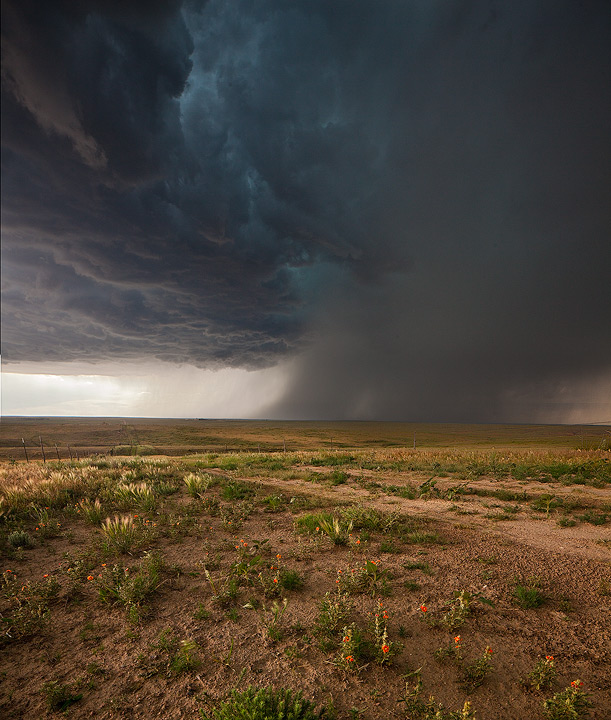
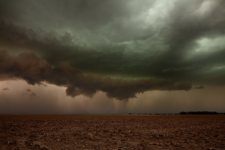
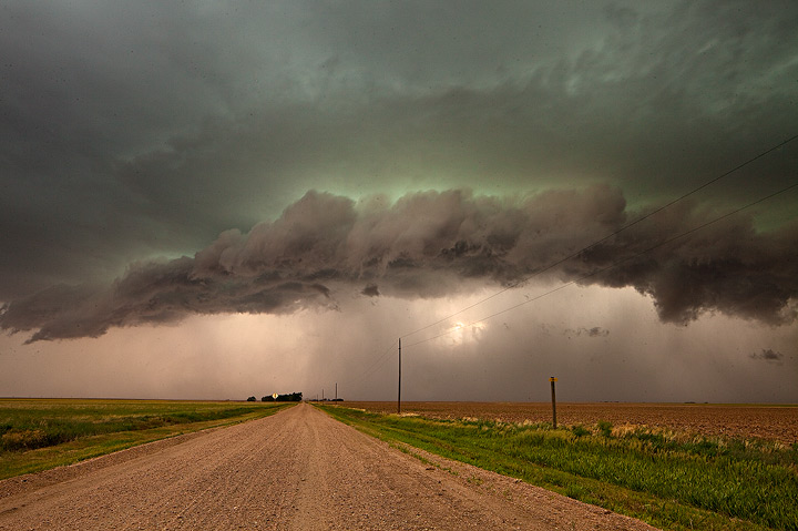
All the storms were expected to form along a line, developing along a cold front that was advancing from the north and west. Cold fronts are not the favorite of chasers, because storms tend to form along a line, which makes it difficult to target any particular storm. Linear storm development also is not very kind to tornado development; it makes it difficult for a storm to organize in a fashion conducive for tornadoes. But I was not expecting tornadoes; I just wanted to see and photograph some pretty storms, and it now looked like my best bet was south, so I raced southward from Hays to catch the more isolated storms that were forming to the south and west. I got about 30 miles northeast of Dodge City when a tornado warning was issued for a storm nearing the city, the only tornado-warned storm of the entire line that now stretched from Oklahoma to Iowa.
To get to that storm, I would have to blast through the northeast side into a wall of hail and heavy rain, something I was not anxious to do. I continued to move southwards along the advancing front, catching another severe storm that looked every bit as dangerous as the storm that was tornado-warned. I pulled over onto a dirt road and set up my camera, as the beast edged closer to me. I looked up and saw rapid rotation in the cloud above, and I half-expected a tornado to drop right then and there. But that is not why I chase. The lighting surrounded my car like a cage, and a shiver went up my spine as the adrenaline kicked in; THIS is why I chase.
A rotating storm rapidly gains on me as I photograph its violence.
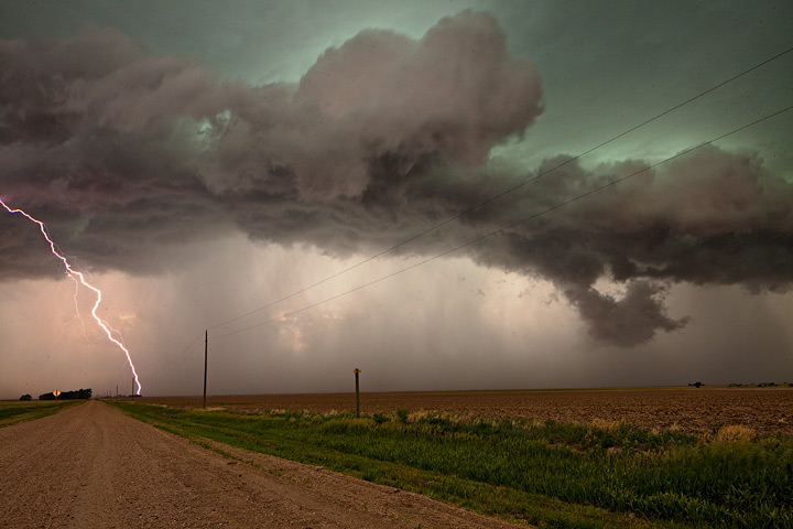
The storms were advancing quickly to the south, into Oklahoma, and I knew that if I kept chasing them I would have a very long drive home. So, I decided to change strategies and head northeast, to get to the backside of the line of storms for sunset. Post-frontal light is some of the best light you can hope for; there is nothing quite like the light and air that follows a severe storm as the sun prepares to set. THIS is why I chase.
Nothing beats a sunset after a line of severe storms have passed.
I spent nearly 30 minutes photographing and taking in the sunset in a part of southwest Kansas I had rarely visited. It was more like New Mexico or the other states to the west, with rolling hills, arroyos, and short buttes. The air was clean and the light was spectacular. THIS is why I chase.
Virga and the setting sun combine to make an abstract painting in the sky.
After sunset, I continued north towards Dodge City. As I passed through the small town of Mineola, I stopped to check out the mounds of hail that covered the streets and lawns. It was over a foot deep in spots—this was not snow but millions of penny to quarter-size hailstones! I was glad that I made the earlier decision not to drive through this hailstorm. Amazing… THIS is why I chase.
Penny to quarter sized hail in piles up to a foot deep cover the town of Minneola, Kansas.
Hail fog is caused when hail on the ground cools the warmer, moister air just above the ground. I’ve witnessed it several times before, but the hail fog in Mineola Saturday night was especially intense and eerie; I’ve never experienced anything quite like it, and it gave me goose bumps. When you storm chase, If your expectations are not to see a tornado, but to see something you’ve never seen before, something that will open your eyes to the incredible beauty that nature provides—you WILL be rewarded. I was rewarded, and the 900 miles or so I drove felt like nothing. THIS is why I chase.
Likely area for accumulating snow Saturday-Saturday night.A low pressure system will move through New England this weekend, bringing with it some unusually cold Canadian air. Snow levels could fall below 2,000 feet, and there could be some accumulating snow in the Eastern Adirondacks of New York, and the Berkshires, Green Mountains, and White Mountains of Massachusetts, Vermont and New Hampshire. Snowfall in excess of six inches will be possible for the higher peaks. Sunday looks like a great day to get out and enjoy the fresh late spring snowfall, as the storm moves to the east. I would love to be in the High Peaks of the Adirondacks late this weekend! Let me know if you make it out for the fun–should make for some great photographs!
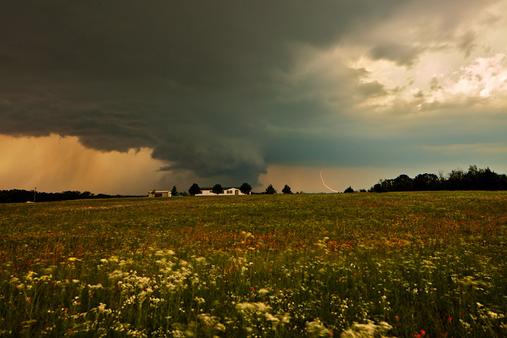
A large wall cloud develops on a monster supercell in Oklahoma. This was the storm just south of the killer tornado that hit Moore on May 20, 2013.
I was in Ponca City, Oklahoma, on the last day of a five day storm chase. 2,400 miles from Colorado to South Dakota and eventually down to North Texas. Monday, May 20th, and it looked like this day would be the most conducive to producing strong tornadoes; the Storm Prediction Center in Norman had already issued a moderate risk for much of eastern Oklahoma. I left Ponca City around 10 am and began driving south towards Ardmore, my target for the day. Ardmore is a town about 60 miles south of the Oklahoma City area. Numerous storm chasers from around the country and world were headed with me south on I-35. As I got south of Oklahoma City, I passed the entourage from the “Great Tornado Hunt”; a Weather Channel group. The air was murky with poor visibility; the humidity was high and I felt like I was ingesting pea soup with every breath. But everything was still–no sign of the impending doom that would strike that afternoon.
When I got to Ardmore, the first storms of the day were already exploding to the west along a cold front. It looked like the most dominant storm would pass north of Ardmore, so I headed back north, then pulled into a rest stop to check the radar. Storm chasing solo is a tricky and sometimes dangerous proposition, since without a dedicated radar screen and GPS mounted on your dashboard (too much effort for my occasional storm chases) you have to frequently stop to figure out where you’re headed. I checked on the radar and saw a small but intense storm to the north, headed towards Oklahoma City. It was in the exact place that the RUC, a computerized forecast model, had predicted it would occur that afternoon. I had discounted that particular forecast in favor of another computer model (the WRF) which predicted stronger storms occurring to the south. But It was quickly becoming apparent that this northern storm meant business.
I turned on the radio to check for warnings, and I was shocked to hear the voice of Gary England, describing reports of a large, rotating wall cloud southwest of the city. Wall clouds are the clouds that produce strong tornadoes. England is a well-known Oklahoma TV personality and weather forecaster, who gained recognition for his on-the-air tornado warnings, particularly the May 3, 1999 killer tornado that struck the city of Moore. I couldn’t believe what I was hearing; at first I thought it was some bizarre dramatization, like an Orson Welles broadcast. But the live broadcast that unfolded was sobering–very quickly the wall cloud metamorphasized into a huge wedge tornado, a mile wide and headed directly towards Moore. England and his crew of spotters in the field were in shock as well; the beast of a storm was following nearly the same path that the 1999 storm had taken. Mass destruction and fatalities were inevitable.
I looked at my map and saw that I was a mere 40 miles south of the tornado–if I gunned it I could probably get south of the beast before it moved away from the area. But I wasn’t really anxious to chase a mile wide EF-4 tornado through city streets that I was unfamiliar with. I decided to stay the course and chase the storm north of Ardmore. That storm developed a large wall cloud, and I was concerned that it might follow suit to ther northern cell, and drop a massive tornado as well. But for whatever reason–we may never know why–the storm I was chasing spared the countryside. A tornado was reported near Pauls Valley, north of Ardmore, but it must have been brief and/or weak, because I didn’t see it.
With the Interstate now closed to the north, I continued south into northern Texas towards another tornado-warned supercell thunderstorm. I continued to listen to the radio reports of the massive destruction in Moore. On the one hand, I was glad I was not part of that horrifying event. It was an ugly black storm and nothing but destructive power to look at. But as a photographer and journalist, I was also dissapointed that I was not present to document and be a part of this somber but historic event. My profession is to warn the public about dangerous weather, and I felt powerless that I was not able to be there for that tragedy and do what I could to help the community. My heart goes out to the victims of the tornado. Nature can be cruel, unforgiving, but it can also be beautiful.